Cyclone is the most versatile point cloud processing software on the market. However, with all of its flexibility comes some complexity. There are many very powerful tools inside that can increase your productivity and save you time, but you may have no idea that they are just waiting for you to put to work. During this live webinar, a panel...
Search results for cyclone
-
Leica Cyclone 7.4
- SCCS HDS is pleased to announce the availability of Leica Cyclone 7.4 The new Leica Cyclone v7.4 software introduces support for the new Leica External Camera Kit for the Leica ScanStation C10 and C5 scanners. In addition it introduces a new option to use gradient display backgrounds for better visualization. - - Companion Office Software for New Leica ScanStation C10 &... -
Leica JetStream and Cyclone 9.1 Now Available
Leica JetStream is a new software solution from Leica Geosystems HDS™ that enables users with Leica CloudWorx to work in real time with full density point clouds in popular CAD environments. JetStream is the only available point cloud solution on the market with unlimited scalability that can effortlessly support projects with thousands of scans and tens of billions of points... -
Efficient Scanning of a Metro Station with the Leica RTC360 Laser Scanner
 From their offices in Macclesfield and Romiley, ScanTech International is an engineering site survey consultancy providing accurate as-built data within the built environment across a broad spectrum of market sectors. ScanTech was one of the first companies in the UK to purchase a portable laser scanner, the Leica HDS 2500 in 2002, which at the time was state of the...
 -
The full laser scan survey of a Grade II* Listed historic building
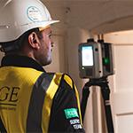 Ridge and Partners LLP is a multidiscipline Property and Construction Consultancy with over 650 employees working worldwide from 11 offices across the UK. In September 2019 their Geospatial team were commissioned by Oxford City Council to undertake a full laser scan survey and produce a Revit 3D Model of the Oxford Town Hall, a grade II* listed building in the...